Annotations
Overview
Annotations are user-authored geographic overlays stored as GeoJSON and reused across the application. They are created and managed on the Annotations page, can be imported or exported as GeoJSON files, and can be displayed both in the Map Window and in the player Video Overlay.
Typical uses include marking routes, points of interest, boundaries, search areas, no-fly zones, and other mission context that should stay visible while reviewing or monitoring video.
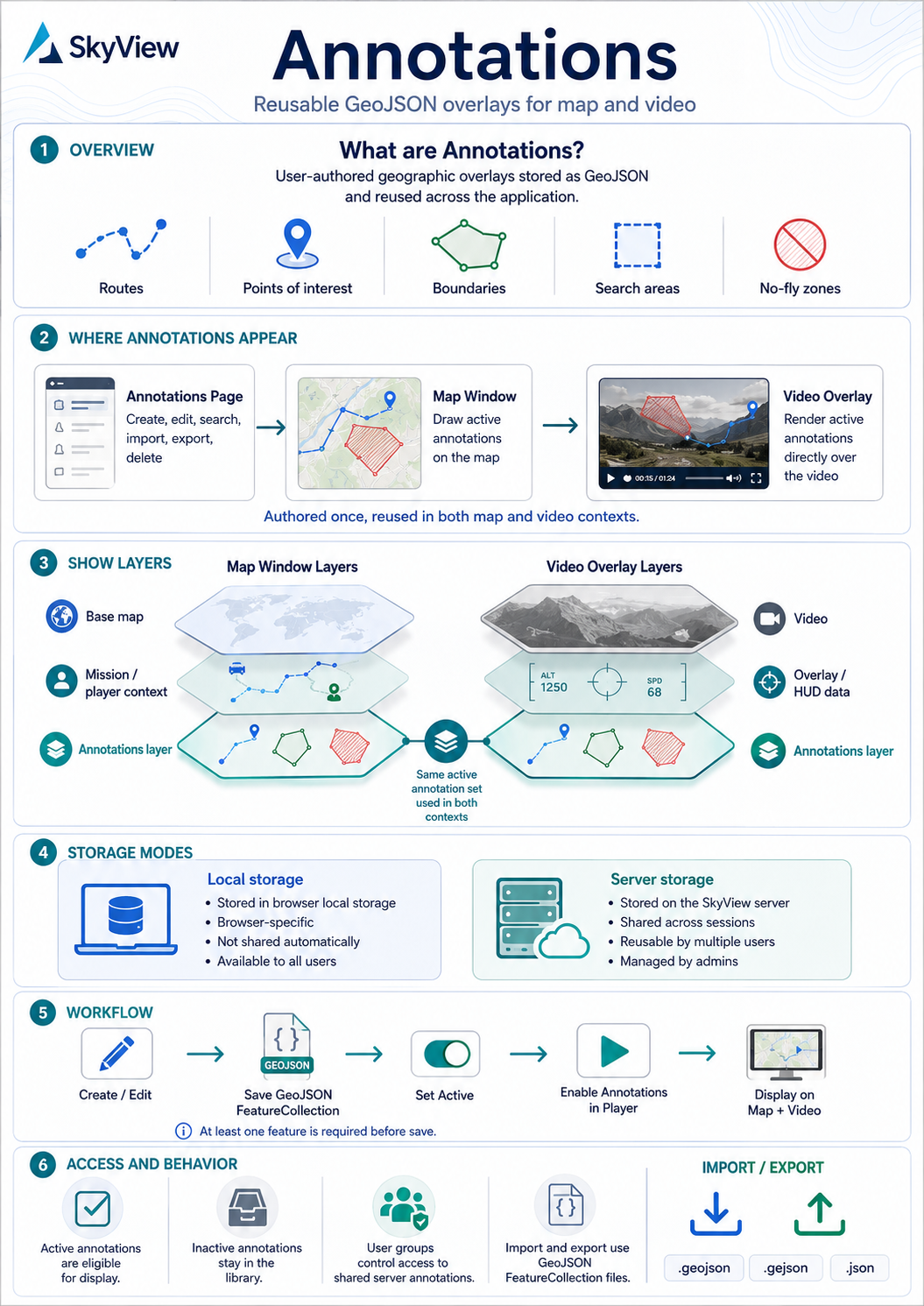
Where annotations appear
- Annotations page: create, edit, search, import, export, and delete annotations.
- Map Window: active annotations are drawn on the map when annotation display is enabled in the player.
- Video Overlay: active annotations can be rendered directly over the video when the annotation layer is enabled.
Annotations are authored once and then reused in both map and video contexts.
Opening the annotations page
Open the Annotations page from the main application navigation.
The page contains:
- a searchable table of available annotations,
- multi-selection for bulk operations,
- actions for add, edit, delete, export, and import.
Annotation list
The list shows the main metadata for each annotation:
- Name
- Description
- Tags
- Storage (
LocalorServer) - Active state
Use the search field to filter the list by name, description, storage, or tags.
Selection behavior:
- Edit works on one selected annotation.
- Delete can remove one or more selected annotations.
- Export exports one GeoJSON file per selected annotation.
Storage modes
Annotations support two storage locations.
Local storage
Local annotations are stored in the browser local storage of the current device and browser profile.
- They are available only in that browser profile.
- They do not require server-side persistence.
- They are not shared automatically with other users or devices.
- Non-admin users can always create and manage local annotations.
Server storage
Server annotations are stored on the SkyView server and are intended for shared use.
- They are available across sessions.
- They can be reused by multiple users, subject to access control.
- Admin users can create, edit, delete, and import annotations into server storage.
- Unrestricted annotations can also be saved to server storage by non-admin users when user management is enabled.
When user management is enabled, only administrators can change the Restricted flag.
Creating and editing annotations
Use Add annotation to create a new annotation, or select one existing row and use Edit annotation.
The editor has two tabs:
- General: annotation metadata and storage settings
- Map: the annotation geometry editor
General tab
The General tab contains these fields:
- Name: required
- Description: optional free text
- Active: controls whether the annotation is eligible for display in the player
- Tags: comma-separated labels for searching and organization
- User groups: groups allowed to access the annotation when user management is enabled
- Storage:
LocalorServer; non-admin users can change storage for unrestricted annotations - Restricted: when enabled, only administrators can later change the annotation or delete it; non-admin users can see the field but cannot change it
Map tab
The Map tab contains an embedded map editor used to author annotation geometry.
- The geometry is stored as a GeoJSON
FeatureCollection. - At least one feature is required before the annotation can be saved.
- The map focuses on the current annotation geometry when possible.
- Creating, updating, or deleting shapes in the map editor updates the saved annotation geometry.
- For restricted annotations, the map editor is read-only for non-admin users.
Authoring is done on this page. The player and map window display annotations, but annotation editing is performed from the Annotations page editor.
Active state
The Active switch controls whether an annotation participates in player display.
- Active annotations can be loaded into the player map and video overlay.
- Inactive annotations remain stored and editable, but are not loaded for player display.
This allows operators to keep annotations in the library without showing them during playback.
Access control and user groups
When user management is enabled:
- Admins can see and manage all server annotations.
- Non-admin users only receive server annotations whose configured User groups overlap with the user groups assigned to that user.
- Local annotations remain local to the current browser.
- Only administrators can turn Restricted on or off.
- If an annotation is Restricted, only administrators can edit it or delete it.
- If an annotation is not restricted, users who can access it can edit it and delete it, except they still cannot change the Restricted field unless they are administrators.
In practice, User groups are the access-control mechanism for shared server annotations.
Importing annotations
Use Import annotations to load one or more GeoJSON files.
Supported file types:
.geojson.gejson.json
Import behavior:
- Each imported file must contain a GeoJSON
FeatureCollection. - Multiple files can be imported in one operation.
- The import dialog allows choosing Local or Server storage.
- Non-admin users can import to server storage only as unrestricted annotations.
- When a non-admin user imports a file whose GeoJSON metadata marks it as restricted, SkyView ignores that restricted flag and saves the imported annotation as unrestricted.
When possible, SkyView derives annotation metadata from GeoJSON properties, including:
- name or title,
- description,
- tags or categories,
- user groups,
- active state,
- restricted state,
- geographic bounding box.
Exporting annotations
Use Export annotations to download one GeoJSON file for each selected annotation.
The exported file includes:
- the annotation geometry,
- name and description,
- storage metadata,
- tags,
- active state,
- restricted state,
- user groups,
- bounding box when available.
Exported files can be archived, shared, or imported again later.
Deleting annotations
Use Delete annotation(s) to remove selected annotations.
- Local annotations are removed from browser storage.
- Server annotations are removed from the server.
- Mixed local and server selections are handled in one delete action when the user has permission to remove them.
- Restricted annotations can only be deleted by administrators when user management is enabled.
Using annotations in the player

Annotations are displayed from the player page.
- Use the Annotations toggle in the player toolbox to enable or disable annotation display.
- The same visibility state controls both the Map Window and the Video Overlay.
- Disabling annotations unloads them from both views.
When annotation display is enabled, the player loads:
- active server annotations the current user is allowed to access,
- active local annotations stored in the current browser.
To avoid loading unrelated data, SkyView narrows the annotation query to the approximate area currently relevant to the player by using live video geolocation and, when available, the current map viewport.
Annotations in the Map Window
When the Map Window is open and annotations are enabled:
- annotations are rendered on the map,
- the current map viewport contributes to which nearby annotations are loaded,
- annotations remain synchronized with the same active annotation set used by the video overlay.
See also Map Window.
Annotations in the Video Overlay
When the overlay annotation layer is enabled and annotations are enabled in the player:
- active annotations are rendered over the video,
- the displayed set stays synchronized with the map,
- annotation geometry is presentation data, not authored directly in the player.
See also Video Overlay.
Operational notes
- Local annotations are browser-specific.
- Server annotations are the right choice for shared operational overlays.
- Inactive annotations stay in the library without appearing in the player.
- User groups should be used to control access to shared annotations when user management is enabled.
- Import and export use GeoJSON
FeatureCollectionformat.