3D View
The 3D View displays the aircraft, sensor direction and ground footprint on an interactive globe using the player's MISB metadata.
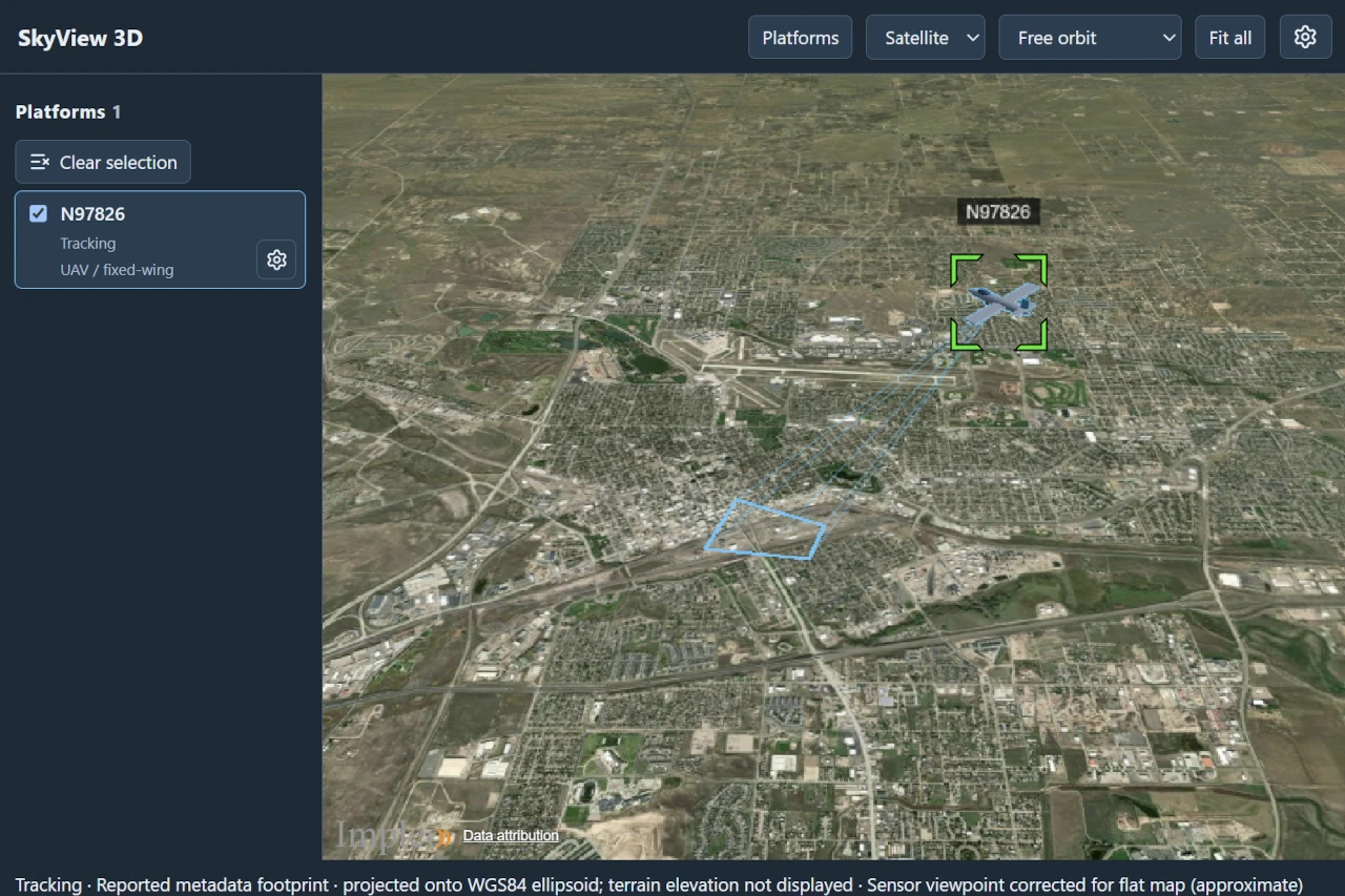
Use the globe button immediately after Map Window in the Player toolbar to open 3D View. The map and 3D windows can remain open together. Closing the player page closes its 3D window. Allow popups for SkyView if opening is blocked.
The window follows the player's current KLV feed. Switching or stopping streams removes the previous platform and detections. This version does not aggregate other players or streams. Rendering libraries, workers, models and terrain are loaded only after opening the window, including when SkyView is installed as a PWA.
Navigating
Choose Free orbit, Follow platform, or Sensor view. Sensor view requires complete orientation and field-of-view metadata, or applicable stationary-camera fallbacks. It does not project video onto terrain. Fit all frames the aircraft and footprint. Sensor zoom changes only the viewpoint; Reset zoom restores the reported FOV.
- Free orbit lets you navigate the globe independently of the aircraft.
- Follow platform keeps the selected platform in view as telemetry changes.
- Sensor view looks from the sensor using its orientation and field of view. Scroll over the globe or use + / − to zoom. Zoom changes neither the video nor the ground footprint.
- Fit all brings the platform and its footprint back into view.
Select the platform in the left panel before following it. If only one platform is available, choosing Follow platform or Sensor view selects it automatically. Clear selection returns to Free orbit. Use Platforms to show or hide the left panel, its collapsed state is remembered.
Models and presentation
The platform panel shows visibility and metadata status. Use its Config button
for names, models, scale, alignment, stationary-camera position/mounting fallbacks,
VMTI visibility and frustum appearance. The shared editor has Model, VMTI and
Frustum tabs, and an interactive model preview. Save applies the draft.
Close discards it. Use source settings removes a platform override.
- Click the platform card's Config gear.
- Choose Global fallback, the stream's source defaults, or its player feed in the selector.
- Adjust the Model, VMTI and Frustum tabs.
- Choose Save to apply the changes together, or Close to discard them.
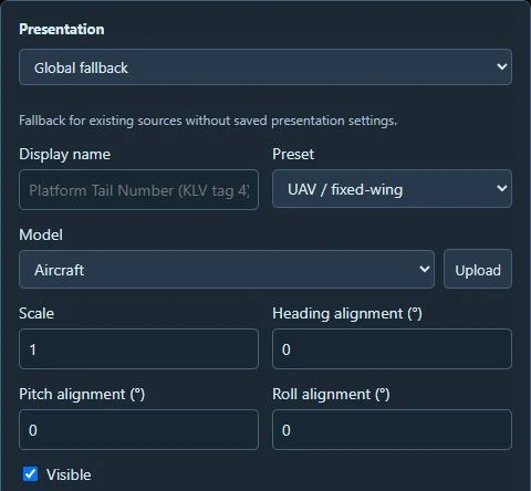
The presets are UAV / fixed-wing, Helicopter, Quadcopter and Stationary camera. Bundled models also include Heron, Cessna, Helicopter and Reaper. Model scale changes the displayed size. Heading, pitch and roll alignment offsets correct differently authored models without changing sensor pointing.
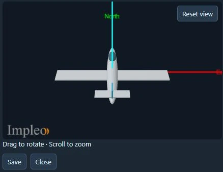
Drag to rotate, scroll to zoom, and choose Reset view to restore the preview camera.*
For a stationary camera, configure a fixed position and mounting attitude as fallbacks when the corresponding telemetry is absent. Fixed height is in metres above the WGS84 ellipsoid.
Presentation settings inherit from global fallback to stream defaults to the player-feed override. They affect 3D only. Missing coordinates and altitude are not invented, incomplete telemetry can show a platform in the list without an aircraft. MSL height uses the bundled EGM96 approximation. Live telemetry becomes stale after five seconds without new data, old detections disappear.
Frustum appearance
In Presentation > Frustum, expand Footprint or Aircraft-to-ground lines to change their Color, Thickness and Opacity. Thickness ranges from 0.5 to 10 pixels. These settings apply to the selected source or player feed.
Reset frustum appearance restores the defaults in the draft. Choose Save to retain them. Closing the editor without saving discards the edits.
Target location
When KLV tags 40–42 report a target location, 3D View draws a crosshair at the target and a connecting line when aircraft position is available. Target location is independent of the frame center and VMTI detections. Latitude and longitude are required; without target elevation, the crosshair is placed on the ground.
Use Presentation > Target > Show Target for the selected source or player feed. Color, line thickness, and crosshair size are available there too. Choose Save to retain the settings in this browser profile.
VMTI targets
Use Presentation > VMTI > Show VMTI targets to control target display for the selected source or player feed, then choose Save. Targets also follow the platform's visibility setting.
- Solid green outlines show reported geographic contours or bounding envelopes.
- Dashed amber outlines show estimated extents projected from image pixel boxes.
- Small markers show targets with a known location but no usable extent. Green indicates a reported location, amber indicates an estimate.
Hover over a target for its ID and placement method. Pixel-only placement needs VMTI image dimensions and a complete ground footprint. Missing or invalid geometry cannot produce estimated boxes. Projection approximates the ground as a plane, terrain, buildings and elevated objects can affect its accuracy. Use these outlines as situational context, not measurements of an object's physical size.
Terrain, imagery and assets
Configure provides Satellite, Map and custom imagery, terrain URLs, XYZ/TMS layout and projection, attribution and offline mode. Satellite is the default, the default terrain is the WGS84 ellipsoid. Optional Cesium ion terrain, buildings, Bing aerial and Google Photorealistic layers require your own token and are off initially. Provider credits remain visible. Errors do not stop video playback.
Use the toolbar's Satellite / Map selector to switch between Esri satellite imagery and OpenStreetMap streets. Open the Configure gear for Map content and Advanced: terrain and imagery. Choose Save to apply the configuration or Cancel to discard the draft. The toolbar's base-layer selector is disabled while editing configuration, in offline mode, or while Google Photorealistic 3D Tiles is selected.
Optional Cesium online content
In Configure > Map content, enter your Cesium ion access token, then enable the required layers: Cesium World Terrain, Cesium OSM Buildings, Bing Maps Aerial imagery, or Google Photorealistic 3D Tiles. The token must have access to the selected content in your Cesium ion account.
Tip
Create or manage your access token in your Cesium ion account. A token is required to use these optional layers, the default Satellite and Map backgrounds do not require one.
Custom terrain takes precedence over World Terrain. Clear the custom terrain source to use World Terrain. Google Photorealistic 3D Tiles replaces the visible globe and buildings while enabled. Turn it off to return to the configured base layer. Sensor and target calculations still use terrain or the ellipsoid, not the photorealistic mesh.
The token field is masked. Use its trash button to remove the token, confirm, and choose Save to keep the change. Removing the token disables its online layers. Cancel discards the configuration edits.
Offline terrain and imagery
Offline mode suppresses online layers. Use registered datasets or explicitly local servers. Without imagery it displays a plain globe. Local datasets require SkyView's OfflineMap capability and enabled offline maps. Footprints intersect terrain or the ellipsoid, not building roofs or photorealistic meshes.
For terrain, use a terrain server URL or a registered folder containing
layer.json and its quantized-mesh or heightmap tiles. Datasets must be
self-contained. Raw elevation files and GeoTIFFs need conversion to tiles first.
For imagery, supply an HTTP(S) tile template such as
http://localhost:8000/{z}/{x}/{y}.png, or register a tile folder. Set the image
format, maximum level, XYZ or TMS layout, projection and attribution to
match the dataset. URLs are loaded by the viewing browser, localhost refers to
that browser's computer. Keep registered folders available on the server.
Importing models and registering datasets
Administrators can upload GLB models or select a glTF folder with its buffers and textures. Imports are limited to 256 MiB and 1,024 files and cannot reference files outside their import. The library includes UAV, helicopter, quadcopter and camera presets and the additional bundled aircraft listed below.
Administrators can register terrain and imagery folders on the SkyView server,
below Host Media. Relative paths start at Host Media, absolute paths must remain
inside it. Terrain folders need a self-contained Cesium layer.json, imagery
folders use {z}/{x}/{y} tile layout. Registration keeps files in place. Remote
browsers cannot register a folder on their own computer. Viewers can use shared
assets but cannot upload or register them.
To import a model, open the platform's Config gear and choose Upload beside Model. Select a GLB file or a folder containing the glTF file, textures and buffers. If the folder contains several models, choose the model entry before uploading. The imported model is selected in the draft, choose Save to retain the presentation selection. Closing without saving does not remove the uploaded asset from the shared library.
Metadata accuracy
Aircraft position comes from sensor latitude, longitude and altitude, not the frame-center coordinates. WGS84 ellipsoid altitude is preferred. MSL altitude uses the bundled EGM96 approximation. Missing position or altitude prevents placement. Incomplete attitude can leave a position marker instead of an oriented aircraft.
Reported frame-center and corner coordinates define the ground footprint when available. On the default flat globe, they are projected onto the map surface. The status line identifies this approximation. Sensor view requires complete sensor orientation and field of view, or applicable stationary-camera fallbacks.
An Off earth endpoint hides the affected rays and footprint edges. Valid adjacent edges remain visible, the footprint fill requires all four corners. Without reported corners, sensor geometry can estimate intersections with loaded terrain or the ellipsoid. Check the status line for incomplete or approximate geometry. These displays are situational context, not surveyed targeting products.
Troubleshooting
- No window opens: allow popups for SkyView and try the globe button again.
- Waiting for metadata: check that the player has a running stream with KLV.
- Platform listed but no aircraft: inspect the metadata status for missing coordinates, altitude or attitude, and check the platform's visibility.
- Sensor view unavailable: check sensor orientation and field-of-view data.
- Missing model or dataset: choose an available replacement in Presentation or Configure, or restore the asset on the server.
- Online layer fails to load: check connectivity and the ion token's asset access. Offline mode suppresses online layers.
Where settings are saved
Selections, presentation overrides and ion settings are saved in this browser's local storage, separately for each server and signed-in user. Different clients can choose different settings simultaneously. Windows in the same browser profile share saved preferences. Clearing site storage resets them, they do not modify the server's global configuration.
Uploaded models are stored below Host Media's scene-assets/ directory. The asset
registry is stored in SkyView's database. Back up both along with registered
terrain/imagery folders. Removing a dataset externally leaves a missing-asset
message, choose a replacement in Configure or Presentation.