Ruler
The Ruler tool measures distance directly in the video overlay. Use it when a source has usable geospatial metadata and you need an approximate ground distance between two visible points in the scene.
Open the tool from Tools > Ruler in the transport controls. STView draws a line over the video with draggable endpoints. Move the endpoints to the points you want to compare and read the distance label shown with the ruler.
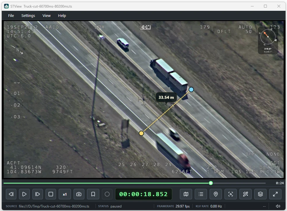
Geo-Aware Measurement
The ruler is geo-aware: it uses the current packet georeferencing to translate the two image positions into ground-referenced points, then reports the distance between those points.
The endpoints themselves are saved as image-space positions. This keeps the line attached to the same places in the video frame while you review playback. As the source metadata changes from packet to packet, STView recalculates the ground distance using the georeferencing available at the current playback position.
This behavior is useful for video analysis because the same two pixels can represent different real-world distances when platform location, sensor angle, zoom, terrain projection, or frame georeferencing changes.
Basic Workflow
- Open a video source with KLV geospatial metadata.
- Make sure overlays are enabled.
- Open Tools > Ruler.
- Drag the start and end handles to the two points you want to measure.
- Seek or step through the video to see the measurement update as metadata changes.
The ruler remains draggable while it is enabled. It is available in both presentation and editor-style overlay use, so you can measure without switching into full overlay layout editing.
Metadata Requirements
The ruler needs frame georeferencing before it can calculate ground distance. STView can use either:
| Metadata | Meaning |
|---|---|
ST 0601 Tags 82-89 | Full-frame corner georeferencing. |
ST 0601 Tags 23 and 24 plus 26-33 | Frame center latitude/longitude with offset-corner metadata. |
When the active packet carries ST 0601 Tag 101 Amend Local Set data, the
Player LS selector controls which metadata branch is used for the ruler. Use
the same branch you are using for other overlay or KLV inspection so the
measurement comes from the expected effective metadata view.
Interpreting Results
Treat ruler values as metadata-derived scene measurements, not manual pixel counts. Accuracy depends on the source georeferencing, timing alignment, platform telemetry, sensor model, and how well the chosen endpoints correspond to points on the projected surface.
If georeferencing is missing or cannot project the endpoints into ground space, the ruler may remain visible but cannot produce a meaningful geo-aware distance. Move to a packet with usable metadata or verify the source KLV fields in the KLV window.
Notes and Limitations
- The ruler measures ground-referenced distance from the current metadata; it does not burn measurements into exported video.
- The line uses image-space endpoints, so the displayed distance can change as metadata changes even if the handles are not moved.
- Measurements are most reliable when both endpoints lie on the same projected terrain or ground plane represented by the source metadata.
- Use the Grid tool when you need broader terrain orientation context in addition to a single distance measurement.