3D View
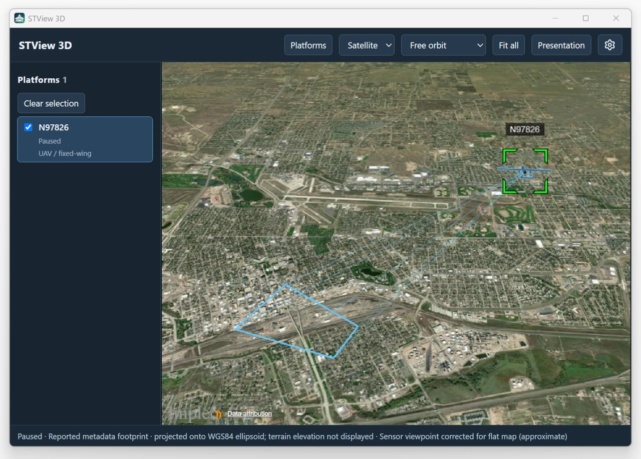
Use the globe icon (tooltip 3D) on the player toolbar to open or hide the separate 3D window. Map and 3D can remain open together.
The Configuration and Presentation controls use STView's dark color scheme, including dropdown menus on Linux.
Create a Cesium ion account (free) to get an access token for terrain, imagery, and Google Photorealistic 3D Tiles. Sign up at ion.cesium.com.
The window displays platforms from all open streams, including mission streams. Each source and KLV PID has its own platform, matching PID numbers in different sources remain separate. Selecting a platform does not change video playback, the overlay's PID, or the KLV window's selection.
Navigating
- Fit all frames all visible platforms together with their sensor rays and ground footprints, leaving space around the scene for aircraft models and labels.
- Free orbit lets you navigate the globe independently.
- Follow platform keeps the selected platform in view. After Clear selection, camera mode returns to Free orbit. When only one platform is available, Follow platform and Sensor view remain available (subject to the sensor data requirements below), choosing either selects that platform automatically. With multiple platforms, select one first.
- Sensor view looks from the selected sensor using its orientation and FOV. It requires complete metadata and does not project the video onto terrain. On the default flat globe, its viewpoint is corrected using the reported target elevation or slant range so elevated ground does not make it look beyond the footprint. This is marked approximate, configured terrain uses the actual sensor position. Scroll over the globe or use + / − to zoom in and out while keeping the sensor's position and pointing direction. Reset zoom restores the reported sensor FOV, selecting another platform or re-entering Sensor view also resets zoom. The camera follows position and orientation changes gently with a 600 ms smoothing response, while zoom responds faster (120 ms). The footprint and sensor lines also ease between updates. The camera settles at the latest reported pose when updates stop, without predicting further motion. Zoom affects only this view, not the video or ground footprint.
In Free orbit and Follow platform modes, platform models and position markers ease toward new positions and orientations with a 600 ms response. Follow tracks the eased platform, and sensor rays stay attached to it. In all view modes, the footprint fill, outline, center ray, and corner rays ease together with the same 600 ms response. Ground points remain on the displayed surface. Missing intersections disappear immediately rather than leaving stale lines behind. Free orbit leaves the camera under your control. Large position jumps and newly opened sources appear immediately.
The platform list shows each source/PID, model preset, visibility, and metadata status. Paused playback lets the display settle at the last reported pose without predicting further movement. A live platform with no new telemetry for five seconds is marked stale. Stop or source removal clears its platforms.
Use Platforms in the toolbar to show or hide the left panel, just as Configure toggles the right panel. The window remembers whether the platform list was collapsed or expanded the next time you open it.
Use the Config gear at the bottom-right of a platform card for platform names, models, VMTI targets, and frustum appearance. It opens Presentation with that platform's KLV PID selected, without changing scene selection or the camera. Click its Config gear again to close the editor; clicking another platform's gear switches the editor to that platform. Closing without saving discards edits. You can also choose source defaults or another KLV PID in the editor, then switch between Model, VMTI, and Frustum below the selector. Switching tabs preserves edits; Save applies all tabs together. The model preview appears only in Model. Use source settings removes the complete PID override.
Use the Configure gear button for map content, terrain, and imagery.
Map content starts expanded.
Advanced: terrain and imagery starts collapsed.
Save and Cancel apply to this configuration panel.
Negative altitudes, including flights below sea level, are supported. On the default flat globe, platforms below the map surface use an approximate height above the target ground, based on target elevation or target location and slant range. The status identifies this approximation, the original altitude is kept. Terrain containing the actual ground elevations uses the reported platform position directly. Ground footprints can be shown without target elevation, but Sensor view still requires complete sensor orientation, including roll.
Models and configuration
Choose a platform's Config gear to edit its KLV PID's shared override in Presentation. That platform is selected in the editor initially; the selector also provides source defaults and other KLV PIDs. Save display name, visibility, preset, model scale, and heading/pitch/roll alignment. Use source settings removes a PID override. Settings are remembered by source and PID and update both Map and 3D, including while paused. The Open Stream/File Presentation tab sets the source defaults before opening. The Global fallback entry preserves defaults for existing sources without saved presentation. Newly configured sources start as UAV / fixed-wing.
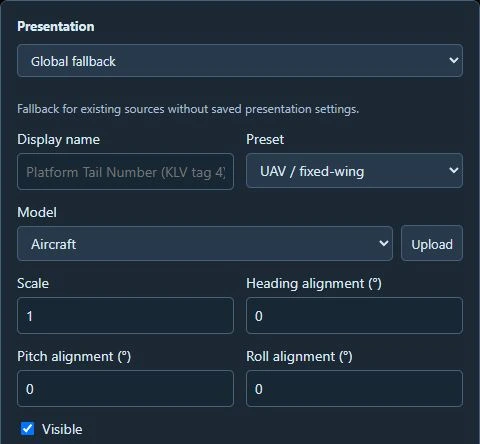
Presentation settings. Choose the source defaults or a KLV PID in the top selector before editing, this example shows Global fallback.
The interactive preview lets you rotate and zoom the model, adjust scale and alignment, and Reset view. Canceling an opening dialog or closing an unsaved presentation editor discards edits. Imported assets remain in the model library.

Drag the preview to rotate the model and scroll to zoom. Scroll down in the editor if needed to reach the preview and Save button.
The bundled presets are UAV / fixed-wing, Helicopter, Quadcopter, and
Stationary camera. The default is UAV. Click the Upload button next
to Model, then choose a .glb or .gltf file. For glTF, local buffers and
textures are included automatically. The model is copied to STView's writable
model library, selected immediately, and listed under Uploaded models in
all presentation editors. Save the presentation to retain the selection.
The Model selector also lists Bundled models, including Cessna,
Helicopter, Heron, and Reaper, separately
from uploaded models. Bundled models ship with STView and work offline without an
import. This list includes all compatible GLB and glTF models shipped in the
bundled-models folder and its subfolders, sorted by name. Heron uses a light-gray aircraft finish with darker engine details and is
aligned to the standard model axes, leave alignment offsets at zero initially.
The three additional aircraft have been uniformly scaled to roughly match
Heron's overall size. Their proportions are preserved, model size is for display,
not a measurement of the real aircraft.
Aircraft uses the model for the selected preset. An individual PID override
takes precedence over the source setting, select the bundled Heron in that
override too, or choose Use source settings, to replace an older imported model.
The model's expected axes are nose +X, up +Y, right +Z in glTF coordinates. Use alignment offsets for differently authored models. These offsets change the model only, they do not change sensor pointing. Distant models have a minimum screen size and should not be used to measure the physical size of a platform. The model uses platform heading, pitch, and roll from telemetry, including the full-range pitch/roll fields when available. Heading turns the nose, positive pitch raises it, and positive roll lowers the right wing. Position comes from the reported coordinates. Heading may differ from the direction of travel.
For stationary cameras, fixed position and mounting attitude can be configured as fallbacks when the corresponding telemetry is absent. Fixed height is in metres above the WGS84 ellipsoid.
Frustum appearance
Open Presentation > Frustum. The Footprint and Aircraft-to-ground lines sections each have Color, Thickness, and Opacity controls. Both sections start expanded and can be collapsed without losing edits. Thickness is 0.5–10 pixels; opacity ranges from invisible to fully opaque. Stale platforms retain their gray status color.
Settings apply to the selected source or PID. Reset frustum appearance restores the library defaults in that draft; choose Save to keep them. Existing global appearance settings remain the fallback until overridden. Closing without saving discards the edits.
VMTI targets
Presentation > VMTI > Show VMTI targets is enabled by default. Change it and choose Save for the selected source or PID. Other platforms retain their own settings. Targets also follow their platform's visibility setting.
- Solid green outlines show reported geographic contours or geographic bounding envelopes. Latitude/longitude offsets use the packet's frame center.
- Dashed amber outlines show an estimated extent projected from the image's pixel bounding box. If a reported target location exists, it anchors the estimate.
- Small markers show targets whose location is known but whose extent cannot be determined. Green means reported location, amber means estimated location.
Hover over an outline or marker for its target ID, source and placement method. Fit all includes targets, even when aircraft position is unavailable.
Pixel-only placement requires VMTI image dimensions and a complete ground footprint. Four valid reported corners are sufficient, otherwise complete sensor geometry can reconstruct the footprint. STView uses one perspective mapping per frame, so boxes may appear skewed when viewed at an angle. Invalid, crossed, incomplete and off-earth footprints do not produce estimated boxes.
This mapping approximates the ground as a plane. Outlines are sampled onto loaded terrain (or the ellipsoid where unavailable), but this does not correct image displacement caused by hills, buildings or elevated targets. These outlines are situational context, not measurements of an object's physical dimensions.
Targets use fresh, presentation-aligned metadata. A new packet without VMTI, an empty target list, or a metadata error clears them. Pause keeps the current frame. Seek, stop, source changes and five seconds without live metadata clear old detections. Target IDs are independent for each stream and metadata PID. SDK builds without fresh packet fields cannot display this layer reliably and leave it empty, platform telemetry continues to work.
Terrain and imagery
Use the Satellite / Map selector at the top of the 3D window to change the background. Satellite (Esri World Imagery) is the default. Map shows OpenStreetMap streets. The choice is saved for the next session. The globe uses the WGS84 ellipsoid.
Open Configure > Map content for optional Cesium layers and offline mode. Use Advanced: terrain and imagery for custom terrain and imagery sources. Custom imagery means your own tile server or local tile folder. Existing custom sources are preserved. Select Satellite or Map to return to a built-in background. The toolbar selector is disabled while editing configuration or using offline mode.
To use terrain, configure a terrain server URL, or register a local folder
containing layer.json and its quantized-mesh or heightmap tiles. Local
datasets must be self-contained, remote parent layers are not supported.
For imagery, configure an HTTP(S) tile template such as
http://localhost:8000/{z}/{x}/{y}.png, or register a folder of PNG/JPEG/WebP tiles with
that directory layout. Set its image format, maximum level, and Web Mercator or
geographic projection (two root tiles across). Choose XYZ or TMS and supply
the required attribution. Local folders are used in place, so keep them available.
Raw elevation files and GeoTIFFs must be converted to tiles before use.
Enable Offline mode to use only selected folders or explicitly configured
local servers. Local servers must use localhost, a private IP address, or a
.local hostname and permit requests from the application. Offline mode never
falls back to public imagery. The renderer, presets, workers, and altitude grid
are bundled with STView. Without imagery, the globe uses a plain surface.
Metadata accuracy
Platform position uses sensor latitude/longitude and altitude. Frame-center coordinates are never treated as aircraft position. WGS84 ellipsoid altitude is preferred. MSL altitude is converted using the bundled EGM96 15-minute geoid grid. That conversion is approximate and does not replace local survey datums.
Missing position or altitude prevents placement. Missing platform attitude uses a position marker. Complete platform and relative sensor angles orient the sensor. Frame-center-only metadata can show a direction line, but cannot supply sensor roll or enable Sensor view.
Demo licensing omits altitude and sensor metadata. In that mode a source may appear in the list without a model, the window explains the missing position or altitude rather than inventing a height.
The ground footprint uses reported frame-center and corner coordinates when available, matching their location on the 2D Map. These coordinates are projected onto the displayed map surface. With the default flat globe, ground elevation is not displayed, the status line identifies this projection. Sensor view continues to use the reported platform and sensor angles.
If a frame-center or corner coordinate reports Off earth, only rays to that endpoint and footprint edges touching it are hidden. Valid rays and edges between adjacent valid corners remain visible. Offset corners require a valid frame center. Full corner coordinates can be displayed independently. The footprint fill appears only when all four corners are available. Hidden parts return when valid coordinates arrive, off-earth endpoints are never replaced with estimates.
Without reported corners, FOV ground intersections use currently loaded terrain. On a flat globe, the estimate uses the reported target elevation or slant range when available, so elevated targets are not extrapolated down to sea level. The status line indicates incomplete or approximate intersections. These displays are situational context, not surveyed targeting products. A terrain or model loading error is shown in the window, playback continues independently.
Optional Cesium online content
In 3D View > Configure > Map content, paste your own Cesium ion access token and select Cesium World Terrain, Cesium OSM Buildings, or Bing Maps Aerial imagery, or Google Photorealistic 3D Tiles. All four are optional and off by default. Map content can be expanded or collapsed by clicking its heading. To remove a token, click the trash icon beside Cesium ion access token and confirm removal. This clears the token and disables its online layers; click Save to remove it from the local configuration, or Cancel to discard edits. Clearing the token also removes Bing Aerial from the imagery lists and switches an active Bing selection to Satellite. Cancel restores the saved selection. Save applies the layers and stores the token in STView's local configuration; Cancel discards edits. The token field is masked. Use a token limited to the required Cesium assets. Existing users keep their current map sources.
Bing becomes the selected base layer and can be switched from the toolbar. Custom terrain URLs or folders take precedence over World Terrain. Clear the custom terrain source to use World Terrain. Offline mode suppresses all Cesium online content. A missing token prevents saving enabled online layers; invalid tokens or unavailable assets produce a map loading message.
Terrain and imagery resolution varies by location. OSM Buildings is a visual layer; sensor footprints and targets are projected onto terrain, not roofs.
Google Photorealistic 3D Tiles uses the same ion token. Enable Google's asset in your Cesium ion account and grant this token access. Once loaded, Google's ground and buildings replace the visible globe and OSM buildings. Turn Google off to restore the configured base layer; the base-layer toolbar is disabled while Google is selected. Offline mode disables Google too. If initialization fails, the configured map remains visible and an error is shown.
Google is a visual layer. Sensor and target calculations still use terrain or the ellipsoid, not Google's mesh, so overlays can be obscured by its surface.
Accounts, tokens, and billing
For the Bing Maps Aerial imagery and Google Photorealistic 3D Tiles options in STView, you only need a Cesium ion account and access token. You do not need a separate Microsoft/Bing Maps account, Google Cloud account, or provider API key. Add the desired content to your Cesium ion account and allow your token to access it. The same ion token can authorize both providers.
Cesium ion provides access to this third-party content through its service. Usage from STView counts against the Cesium ion account associated with your token. Any Cesium subscription payment is made to Cesium; these options do not create a separate Google or Microsoft bill for you. The commercial arrangements between Cesium and the content providers are managed by those companies.
A token is required even on a free plan. Cesium offers a free Community plan for eligible personal, educational, and evaluation use, subject to usage limits. Production commercial or government use may require a paid plan under Cesium's eligibility rules. Plans include quotas: Bing imagery counts toward the Global Imagery session quota, while Google Photorealistic 3D Tiles has a separate root-tile quota. Check your ion account's usage and current plan terms when deciding which layers to enable.
See Cesium ion pricing, quotas, and eligibility, Google 3D Tiles access through Cesium ion, and the content usage and attribution guide for the current requirements. This account and billing explanation applies to STView's Cesium ion options; custom map services use their own provider terms.