Maps
Maps
Online Maps
- STANAG On Demand Server can use online maps from different providers
 Selecting the map
Preconfigured Maps
The server uses some pre-configured map sources. You may change the configuration in the config.json file (/StServer/data folder)
{
"layers": [
{
"title": "OpenStreet Maps",
"tileLayer": "http://{s}.tile.osm.org/{z}/{x}/{y}.png",
"attribution": "© <a href=\"http://osm.org/copyright\">OpenStreetMap</a>"
},
{
"title": "Thunderforest Landscape",
"tileLayer": "http://{s}.tile.thunderforest.com/landscape/{z}/{x}/{y}.png",
"attribution": "© <a href=\"http://www.opencyclemap.org\">OpenCycleMap</a>, © <a href=\"http://www.openstreetmap.org/copyright\">OpenStreetMap</a>"
},
{
"title": "Esri WorldImagery",
"tileLayer": "http://server.arcgisonline.com/ArcGIS/rest/services/World_Imagery/MapServer/tile/{z}/{y}/{x}",
"attribution": "Tiles © Esri — Source: Esri, i-cubed, USDA, USGS, AEX, GeoEye, Getmapping, Aerogrid, IGN, IGP, UPR-EGP, and the GIS User Community"
}
]
}
Offline Maps
- It is also possible to use offline maps when there is no Internet connection available. You have to configure your map server at the Settings page, so the STANAG On Demand Server could be able to access map tiles.
Configuring offline maps
There are many ways to create them (free and paid). One of the easiest would be to use a Mobile Atlas Creator .

Using Mobile Atlas Creator
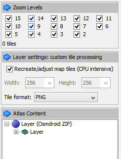
Select the area and required zoom levels you need and save Atlas as OSMdroid ZIP. This will create a zip folder of the image tiles in the format: {atlas_name}/{z}/{x}/{y}.png. Extract this folder of map tiles somewhere and let your map server access to it.